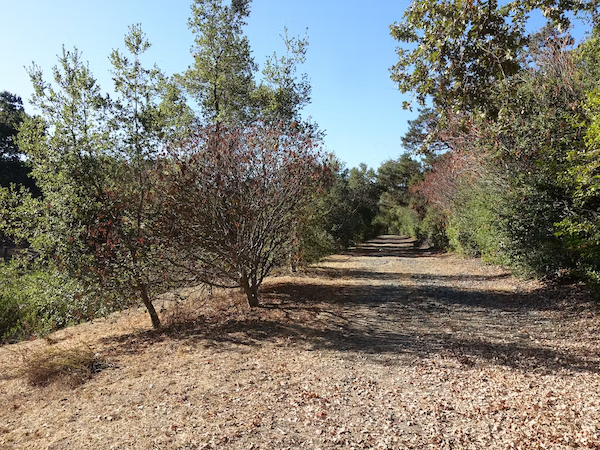
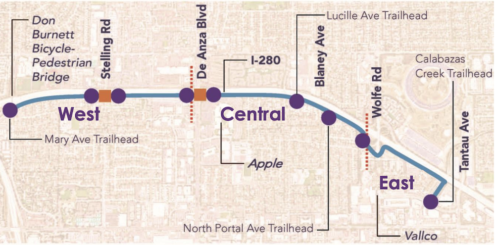
Have you heard of the Tamien Innu? Sometimes referred to as the “I-280 Trail”, and previously named the “Junipero Serra Trail”, it’s a planned off-street trail connecting the east and west sides of Cupertino on its northern side. The trail, when complete, will begin at Vallco Parkway near Tantau Avenue, follow alongside I-280 for three miles, and ultimately connect to the Don Burnett (Mary Avenue) Bridge. Many people are eagerly awaiting this trail for safe and enjoyable walking and biking for recreation or to connect to shopping or dining destinations, such as Main Street Cupertino.

Recently, the city staff have provided updated timing on when construction will begin on the project and what issues they have faced during the design.
Trail construction
The trail has been divided into three segments. The staff is working on these segments in order of their difficulty of implementation.
The name Tamien Innu
This past January, in response to concerns about the previous name, the city staff held a public poll to determine the new name for the trail.
The name chosen by popular vote was Tamien Innu, which means Tamien Trail. This change recognizes and respects those who first occupied the land where the trail will be, the Tamien Ohlone.
The Cupertino Council unanimously approved this name change in March 2023.
East Segment
Vallco Parkway to Wolfe Road This portion has been in the design phase since May 2020 when BKF Engineers was awarded the design contract of $895K for the eastern and central portions of the trail. Both this segment and the Central segment passed CEQA environmental review in March of 2022.Recently, the trail design was revised to mitigate a few unavoidable issues. Valley Water, which owns the land (the city will have a Joint Use Agreement for the Trail) required better maintenance access to the adjacent creek, and there were concerns about the health of adjacent trees. The alternative design changes the foundation footing and pavement material, and is under review by Valley Water.
The bidding process for this portion of the trail is scheduled for early next year. Construction is expected to begin in summer of 2024, with the grand opening in spring 2025.
Central Segment
Wolfe Road to De Anza Boulevard
Because of the issues found in the East segment, staff time was reallocated to address those first before continuing to work. Once approval is received from Valley Water for the design changes made to the East Segment, the Central Segment design work will begin again.
As the CEQA review and design of the East and Central Segment have been so closely tied with both funding and design, it is hoped that the Central segment will be constructed and open at the same time as the Eastern segment.
West Segment
De Anza Boulevard to Don Burnett (Mary) Bridge
This portion has not started design yet. Work on it is deferred until the central and eastern portions have completed construction. It is the most difficult portion, as it includes the crossing of DeAnza Boulevard.
Funding for this Trail
Design costs for the east and central portions were paid for by a $1.8M Apple grant, given in 2019.
In May of 2020, Cupertino received a VTA grant to cover the expected construction costs of $6.1M for the east and central segments. Currently, there is no scheduled funding for the west segment.

We are looking forward to the opening of this trail, and its many benefits for residents of Cupertino and beyond. It will be a long, safe, and enjoyable off-street trail when it is completed. Many residents enjoy our local trails today, such as the Regnart Creek Trail, the Stevens Creek Trail, and the Linda Vista Trail. This will be an excellent addition to them.
The information in this post is solely the opinion of the author and Walk-Bike Cupertino, and does not reflect the opinions of any other organization or entity, including the City of Cupertino.


Comment on the Steven Creek Trail that runs from McClellan Road along the golf course perimeter to Linda Vista Park. It’s a very popular trail ever since it opened and it would be awesome if it can be extended to the Steven Creek County Park.
We agree! The missing section of the Stevens Creek Trail from Stevens Creek Boulevard to the Sunnyvale border is definitely needed. With the improvements coming for Sunnyvale for their stretch of the SCT, there should be more of a push from Cupertino residents to connect our portion to it as well. (See here for more information on the Sunnyvale SCT changes coming: https://walkbikecupertino.org/2023/04/stevens-creek-trail-is-extending-into-sunnyvale/)